Low-Altitude Safety Digital Intelligence Platform
OnlineConsultation

Overall Solution for Low-Altitude Safety Digital Intelligence Platform
With the gradual opening of low-altitude airspace and the continuous favorable policies, the low-altitude economy has become an important direction to promote the development of new productive forces. In response to the growing application demand for low-altitude aircraft and the complex challenges of airspace management, relying on years of technical accumulation in the fields of aerospace, intelligent perception, network communication, and data platform construction, our company has launched the "Low-Altitude Economy Overall Solution" for government, park, and enterprise customers, helping to build a safe, efficient, intelligent, and sustainable low-altitude operation ecosystem.
I. Vision and Goals of the Solution
This solution aims to build an integrated "air-ground-network" low-altitude operation guarantee system, focusing on the four core directions of "monitoring, management, service, and application". It promotes the digitalization of low-altitude airspace management, intelligent operation, and convenient service, comprehensively enabling the implementation of application scenarios such as general aviation, unmanned aerial vehicle (UAV) logistics, emergency rescue, aerial inspection, and low-altitude tourism, and helping local governments seize the opportunity in the development of the low-altitude economy.
II. Core Capabilities of the Solution
1、UAV Control System
Building a visual UAV control platform to realize the whole-process management and dynamic scheduling of aircraft is a core measure to improve the supervision efficiency and safety of the low-altitude economy. The platform integrates multi-source data such as low-altitude radar monitoring systems, electronic reconnaissance data, and UAV nest operation information. Through 3D map visualization technology, it intuitively presents the real-time position, flight trajectory, speed, altitude, mission status and other information of all aircraft in the airspace, forming an "air-space-ground integration" monitoring network.
2、Low-Altitude Perception and Monitoring System
Deploy an air-ground integrated perception network, including radio detection equipment, radar detection, photoelectric identification, ADS-B, 5G base station fusion perception and other equipment. Cooperated with AI image recognition and multi-source data fusion algorithms, it realizes all-weather and full-coverage real-time monitoring of low-altitude aircraft, especially suitable for UAV monitoring and prevention in cities, coastlines, and important facility areas.
III. Typical Application Scenarios
Smart City UAV Supervision: Realize UAV supervision and early warning in urban core areas and key areas to ensure urban low-altitude public safety.
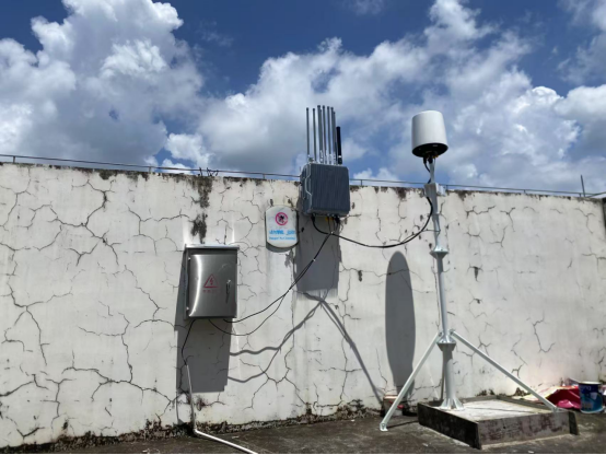
On-site installation diagram of UAV supervision equipment in a certain city
Airspace Perception: Relying on perception means such as radar, radio detection, ADS-B, and Beidou high-precision positioning, build an airspace dynamic perception system to realize all-weather and full-element airspace situation monitoring in areas such as urban sky, border lines, and no-fly zones.
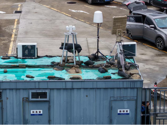
On-site installation diagram of airspace perception equipment in a certain city
Integration of Low-Altitude Culture and Tourism Applications: Relying on aerial photography and low-altitude tourism product design, enrich local new cultural and tourism formats.
IV. Technical and System Advantages
Independent and Controllable: The platform software and core algorithms are 100% independently developed, supporting localized deployment and customized development.
High-Reliability Architecture: The system supports distributed deployment and high-concurrency processing, meeting urban-level and regional-level airspace management needs.
Data Closed-Loop Capability: Realize the full-process closed loop from perception to supervision and then to flight services, improving flight efficiency and safety levels.
Continuous Evolution Support: Support integration with technologies such as Beidou high-precision positioning, 5G/6G communication, AI scheduling algorithms, and digital twin low-altitude cities.
V. Cooperation and Implementation Modes
We provide an integrated construction mode of "platform + equipment + service", supporting on-demand customization, phased deployment, and government-guided market-oriented operation. We have carried out practical projects such as pilot construction of low-altitude management platforms, low-altitude airspace evaluation services, and UAV supervision cooperation in many provinces and cities, and have the ability of rapid implementation and iterative optimization.

ServiceHotLine
0756 8996076

OnlineConsultation

topping